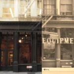
The Green Street Project takes a look at 400 years of Greene Street between Prince and Houston. Based on a report the site brings the data to life through maps, old/new reveals like the one above, charts, movies, and text, in a really nice online exhibit. … [Read more...]
OldNYC brings the New York Public Library NYC photo archive to your phone
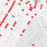
Who doesn't love a large geotagged data set of historical photos? The OldNYC app let's you click on a location and pull images from the NY Public Library's Photographic Views of New York City, 1870s-1970s collection so you can see what the area or building looked like years ago. The app is a mobile version of OldNYC.org which mapped the collection's images after they … [Read more...]
Exploring NYC’s Flower District With Susan Orlean
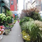
New York used to have many more business specific districts. You can still buy fabric on 38th Street between 7th and 8th Avenues but many of them are gone or diminished as new development takes their place. There were several button stores on Broadway near Prince where you could go the length of a block looking through small boxes filled with every kind of button … [Read more...]